This post has been updated.
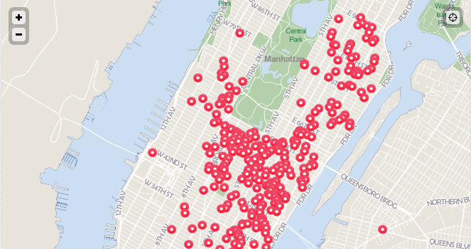
There are more than 500 privately owned public spaces in New York City, most of which are clustered in Midtown, Lower Manhattan and the Upper East and West Sides. You’ll find a fewstragglers around Downtown Brooklyn, and one lonely spot — 1 Court Square — in Long Island City, Queens (think the big, glass Citigroup Building).
As the city increasingly warms to the idea of having private owners provide and maintain public space in exchange for zoning concessions, how can one keep track? This week, the advocacy group APOPS@MAS (Advocates for Privately Owned Public Space at the Municipal Art Society of New York) unveiled an interactive mapping tool allowing users to locate and get info about privately owned public spaces — known as POPS among acronym-friendly planning geeks — throughout New York.
Still in beta, the map lets POPS hunters narrow their search by requiring specific amenities. For instance, if I’m in Brooklyn and want a place to look at artwork while resting my feet, I’ll know I have an option in the MetroTech Center with its 180-plus benches and a sculpture. But if I also want food service and a restroom nearby, I’m out of luck. (In fact, very few of the spaces seem to have restrooms. Weird.)
After clicking through on my desired POPS, I’ll find a more detailed rundown on the place: Background on the designer, architect, and year completed; also nearby subway stops, lighting, water fountains and even individual plant and tree species. Users can leave comments or report a problem on each space as well.
In a blog post, APOPS@MAS founder Jerold Kayden and Municipal Arts Society president Vin Cipolla call on website visitors to speak up in order to make the tool comprehensive and error-free. The site lists about 330 building addresses, at which one can find all of the POPS in New York, according to an email from Kayden.