Shortly after Christmas, New York City unveiled Business Atlas, an online tool meant to help people who’d like to engage in a little local business figure out where to set up shop. The site is still a bit rough around the edges, and much of the data is what you’d expect from a municipal government — population changes, property values, new business openings, that sort of thing.
But one collection of information jumps out: foot traffic. In a city like New York, of course, it can matter a great deal just how many people pass by your place each day. It turns out that the city’s Office of Data Analytics partnered with the local star-tup Placemeter to gather the intel on rates of pedestrianism.
How did Placemeter get that data in the first place?
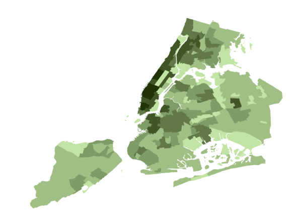
We use a proprietary blend of the Placemeter video network and third-party data sources to gauge pedestrian activity in the City per square meter, getting the resulting map above. The darkest green marks the highest pedestrian activity while the lightest green marks the least amount of pedestrian activity. So, when you want to open that gourmet rice krispies treat shop you can see how active the foot traffic is at one location versus another.
The company has a video showing, in simple terms, how its tracking tools work:
The company is also running a beta project wherein it asks people to “dig out your old, unused smartphone” and put it up in a window to track traffic. Placemeter will even send you a suction cup for mounting.
Government seems like a natural customer for what the company calls “the world’s first real-time dynamic data layer.” Of course, the prospect of tracking people’s movements in real time and then handing that information over to government raises, well, concerns. Placemeter has said elsewhere that its sensors don’t retain any sort of identifying information, but rather pass along raw numbers.
You’ll notice that the data both above and in Business Atlas isn’t enormously granular. All of the Upper West Side is, for example, treated as one place. Savvy city dwellers know that one spot on the street can be a location of death, while one caddy-corner is home to a thriving business. But one imagines that this is a challenge of scale more than anything else. With enough sensors, there’s no immediate technological reasons why — in a city as big as New York, at least — you couldn’t compile finer-tuned data on how humanity moves about.
Postscript: On the question of granularity, Placemeter’s David Fine emails to say that, as far as the company is concerned, its data can be drilled into much further — down, in fact, “to a square meter.” The city’s analytics team has opted, for now, to present the walk statistics aggregated up to the census tract level.

Nancy Scola is a Washington, DC-based journalist whose work tends to focus on the intersections of technology, politics, and public policy. Shortly after returning from Havana she started as a tech reporter at POLITICO.