
In the next five years, the City of Miami needs to build 12,000 new housing units if it’s going to have a chance to address its affordable housing crisis, according to a new report from the city and Miami Homes for All.
If it’s going to meet that goal, it’s going to need a lot of land.
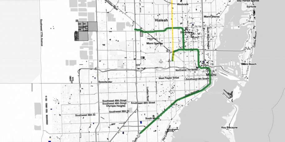
Luckily, according to a new mapping tool developed by the University of Miami Office of Civic and Community Engagement and supported by Citi Community Development, a lot of land is available — at least 500 million square feet, or more than 11,000 acres. (Citi Community Development also provides funding to Next City.) The properties identified on the map are all vacant or underutilized and owned either by Miami-Dade County; a local municipality in the county; or an anchor institution like a university, hospital or religious organization. The tool, called LAND: Land Access for Neighborhood Development, shows potentially available properties overlaid on the city’s transportation grid, along with proposed network expansions. (Note: This online tool was funded by Citi, which also is a funder of Next City.)
“The whole goal in creating this tool was to create a mechanism to promote inclusive and equitable urban development,” says Robin Bachin, the project director and assistant provost for civic and community engagement at the University of Miami. “It’s really putting data in the hands of as many people as possible so that the process of land conveyance can be more transparent.”
Before the LAND tool was available, affordable-housing developers would have to request information from county and local governments to find out about vacant parcels that might be suited for development, says Jorge Damian de la Paz, program manager at the Office of Civic and Community Engagement. The tool was built to make the information available to them for free, and on a rolling basis — the data will be automatically updated every two weeks, reflecting new real estate transactions, he says. And it adds another advantage. Now, when community groups in Miami-Dade County are looking for available land, they can find areas with multiple adjacent underused properties that could be combined for development. The LAND tool allows users to calculate the square footage of adjacent lots owned by different entities.
The tool is also meant to inject a measure of transparency into the city’s process for disposing of vacant land. In the past, Bachin says, some community developers have complained that governments haven’t been completely forthright about pending plans for certain parcels of land, leaving smaller groups at a disadvantage.
“Some community groups have called for this, that there be a more formal structure in the way that public land is conveyed so the process is transparent and so that it’s clear that community-use-value is the number-one priority,” Bachin says.
Community development corporations are of two minds about the LAND tool, says Arden Shank, interim executive director of the South Florida Community Development Coalition. On one side, some groups say the benefits are fairly clear: CDCs can now find available land with less effort than they had to spend before.
“The other side says, ‘Whoa, wait a minute, we’ve got all these big corporate developers that now can swoop in and take this land and put whatever they want on it, and it’s going to hurt our neighborhoods,’” Shank says.
“My personal opinion is, I’m with the former group saying that in the long term, this will help,” he says. “Because most of the large corporate developers, they already knew this stuff! They pay people to find this out. But the rest of us don’t have the money to pay people to do that.”
Bachin notes that the LAND tool is just one among a suite of resources developed by the Miami Housing Solutions Lab at the University of Miami. In 2017, the group released the Miami Affordability Project, a map illustrating the distribution of affordable housing in Miami, intended as “an open-access tool for planners, developers, community groups and scholars of urban issues to better understand local housing needs and encourage data-driven affordable housing planning and analysis,” according to the creators. It has also built a timeline illustrating how government policies have impacted the development of neighborhoods over the years and a policy toolkit meant to help prevent displacement and promote housing affordability.
The LAND tool is meant to give affordable-housing developers and planners a leg up as well, Bachin says.
“We’re very conscious about gentrification pressures, but this tool was designed to level the playing field,” Bachin says. “There are for-profit startups developing these tools that charge a licensing fee, and we wanted to make those sorts of platforms user-friendly, publicly accessible and transparent.”
De la Paz says the bulk of the work that went into creating the map was gathering and cleaning up property data. The group has been working on a series of demonstrations for both CDCs and the Miami-Dade County office of public housing and community development, de la Paz says. Those meetings will help groups figure out how to engage with the data, he says, but most of the work is already done for them.
“It’s almost like playing SimCity,” says de la Paz. “It’s that simple.”
UPDATE: We’ve added language clarifying some of the funding for this tool.
This article is part of Backyard, a newsletter exploring scalable solutions to make housing fairer, more affordable and more environmentally sustainable. Subscribe to our weekly Backyard newsletter.

Jared Brey is Next City's housing correspondent, based in Philadelphia. He is a former staff writer at Philadelphia magazine and PlanPhilly, and his work has appeared in Columbia Journalism Review, Landscape Architecture Magazine, U.S. News & World Report, Philadelphia Weekly, and other publications.
Follow Jared .(JavaScript must be enabled to view this email address)