Scottish landscape architecture firm RaeburnFarquharBowen is adept at producing sustainable solutions. They do so by relying on data as a driving force in the design process.
But they don’t just rely on data for the sake of it. They believe that site analysis needs to be properly integrated with computer-aided design processes; site analysis shouldn’t be a snapshot, senior landscape architect Lisa McRavey indicated, rather it needs to continually inform design iterations and continue to be an integral part of project development. “Data is power,” she emphasized.
The firm lauds the power of geographic information systems (GIS) as a source of truth in their design and analysis.
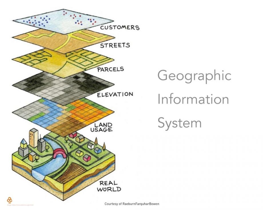
A visualization of how GIS portray real-world conditions.
Rather than importing a PDF of site conditions, McRavey explained that it’s much preferred to directly reference GIS geometry or imagery into Vectorworks Landmark through its access to Esri’s ArcGIS Online feature services. This is because it’s not just a snapshot in time but rather a live overlay of real-world terrain. It’s much more accurate and flexible than the guesswork that comes with positioning and scaling a PDF, McRavey said.
Mapping the Site for Vectorworks Import
McRavey and senior landscape architect Iain Lyon were generous to share some examples of their work at the 2021 Vectorworks Design Day.
One project involved 200 square kilometers of nature with biking and walking paths that nestle alongside nature hotspots, cultural landmarks, and plenty of green escapes from urban life. Members of the firm biked all 200 square kilometers and placed survey discs to map unmapped trails with the Strava app. They were then able to import the GPS-mapped trails into Vectorworks and convert them to shapefiles, allowing them to continue to benefit from geospatially accurate geometry. McRavey said that this was much faster than having to draw the terrain manually, and all that time they saved was relegated to analysis.
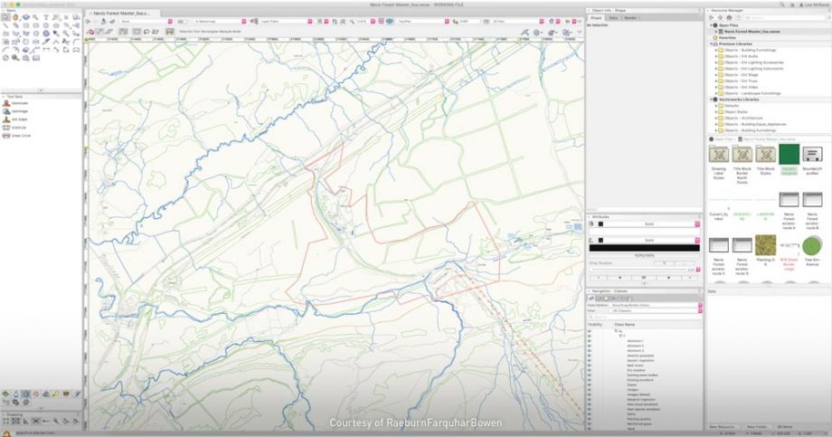
GPS-mapped pathways imported into Vectorworks Landmark.
Cataloging Existing Trees with Purposeful Data
One of the firm’s projects concerned a site with over 600 existing trees that needed to be cataloged before analysis could begin. A seemingly daunting task, but RaeburnFarquharBowen were able to directly import an arborist’s tree survey, after which Vectorworks Landmark generated 2D and 3D canopy representations in correct geographical locations. These representations contained appended data such as maintenance needs and species. With all this information quickly in place, the firm could begin interrogating each tree for various criteria, then quickly demonstrate the scale of these mature trees so the client and consultants could easily visualize them themselves.
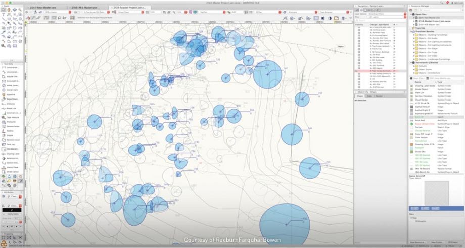
A visualization of mature existing trees, which were imported to Vectorworks Landmark from a site survey.
“Conventionally, tree survey geometry is referenced into the design, but the meat of the data is in a separate report,” Lyon said. “This can get very complicated with so many trees on site. With Vectorworks, the ability to harness technical data and display it visually allowed us to make a case to our design team, the client, and particularly local people for consultations.”
Both example projects mentioned thus far demonstrate the firm’s commitment to carrying site analysis through the entirety of their projects rather than a snapshot analysis that gets left to the doldrums of the beginning phases.
The Limitless Potential of Design Technology
Continuing their expertise with design technology to manage the project process, RaeburnFarquharBowen team members are constantly evolving how they use Vectorworks Landmark.
They’ve made the journey into 3D modeling, which they demonstrated through a residential project with hundreds of homes. Their job was to design the sizable centerpiece pond and its surrounding park. They modeled the area in 3D with Vectorworks and their model was used by a contractor to dig out the pond and create the rest of the park. The firm again spoke to how important it was for this project’s georeferenced data to be supported by Vectorworks so that the project was tied precisely to the real world.

Plan view of community open space designed by RaeburnFarquharBowen.
The firm’s use of technology for intelligent landscape analysis goes even further.
Before the COVID-19 pandemic, they signed on to work on a large urban landscape project in Scotland. The project was set to include dozens of walkways and green areas interwoven with the urban scheme. RaeburnFarquharBowen aimed to involve the local community in the project until the pandemic struck, making it impossible to collaborate in person.
The designers had the perfect solution: following their initial design exploration, they exported the georeferenced Vectorworks file into a cloud collaboration program that allowed the community to comment on different areas of the design.
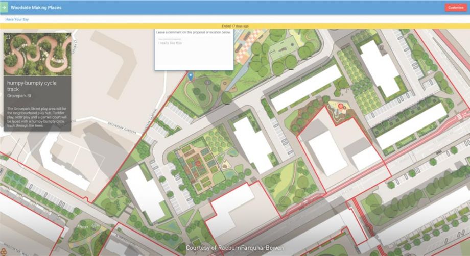
Though McRavey and Lyon would’ve preferred the candor of in-person collaboration, their method for gathering community feedback on this project shows the characteristic power of integrated planning technology for creating adaptable solutions.
RaeburnFarquharBowen’s commitment to a data-driven process has led them to a repeatable pattern of successful projects, a pattern supported by Vectorworks Landmark and its purpose-built site design and planning tools.
Learn more about RaeburnFarquharBowen.
Learn more about Vectorworks Landmark.
Alex Altieri is a copywriting specialist for Vectorworks, Inc. He has degrees in digital/print journalism and philosophy from the Pennsylvania State University, and although he's not a designer by trade, Alex remains inspired by the ways Vectorworks software helps incite creativity.