Are You A Vanguard? Applications Now Open
The Guiwan Park Water Finger Sectional Perspective; Image presented with permission of James Corner Field Operations
This is your first of three free stories this month. Become a free or sustaining member to read unlimited articles, webinars and ebooks.
Become A MemberEDITOR’S NOTE: The following is an excerpt of “Design with Nature Now,” a new book edited by Frederick Steiner, Richard Weller, Karen M’Closkey and Billy Fleming, and published by the Lincoln Institute of Land Policy, in association with the University of Pennsylvania Stuart Weitzman School of Design and The Ian L. McHarg Center for Urbanism and Ecology. This volume celebrates and advances the principles advocated in Ian McHarg’s seminal 1969 work “Design with Nature.” Twenty-five projects are highlighted in the book as those that “best exemplified and extended McHarg’s design philosophy and method.” This excerpt situates McHarg’s vision in the context of our urgent 21st-century environmental reality, and showcases three city projects — in the U.S., China and the Netherlands — that employ McHargian principles for how coastal urban areas respond to water challenges, in particular rising tides.
In 1969, Ian L. McHarg, professor of planning and landscape architecture at the University of Pennsylvania (Penn), published a manifesto titled Design with Nature. Translated into Chinese, French, Italian, Japanese, and Spanish, and still in print to this day, it is arguably the most important book to come out of the design professions in the 20th century. Design with Nature not only captured the zeitgeist of the late 1960s by decrying modern civilization’s — or at least North America’s — sprawling urbanism and environmental degradation; it went further than most by proposing a practical method for doing something about it.
Using rudimentary digital tools and painstaking analog drawings, with his students and colleagues at Penn, McHarg developed a method of overlaying maps of the biophysical characteristics of a given place to make decisions about future land use. Part science and part common sense, the method provided an empirical, rational, and ostensibly objective basis for deciding which land was most suitable for which purpose — for example, farms on the good soil here, forest upland from water supply there, and of course, housing outside of flood zones and behind coastal dunes.
Throughout history, cultures have either withered or flourished as a result of how they live with land and water, or per McHarg, how they designed with nature. For cultures attuned through experience to the specific conditions of their landscapes, designing with nature becomes a form of lore. In this sense, McHarg’s design philosophy is nothing new. But his advocacy of ecology as the basis for design and its application to the modern city was. McHarg’s great achievement, then, was to create a simple, universal method for assessing and then incorporating environmental science into the decision-making processes of modern development. When applied well, his method offered a way to both guide and substantiate design decisions, especially those that limited the scope and scale of otherwise sprawling development.
However, Design with Nature is more than a land-use manual. It soars from geology to cosmology, it cuts from Christianity to Buddhism, and it interleafs speculations on entropy and evolution to arrive at a unifying theory of design. For McHarg, to design with nature meant for humanity to intentionally and benignly fit itself to the environment. Drawing on the most advanced ecological science of his time, this idea of fitness flowed from a belief that cultural and natural systems could coexist harmoniously, in balance, if each part were in its proper place. […] For McHarg, Western culture’s greatest promise was a synthesis of the sciences and the arts that had yet to be applied to how we dwell on the land, and it was the profession of landscape architecture that could steward society through this evolutionary process. To this day, at least in theory if not in practice, this remains the field’s primary raison d’etre.
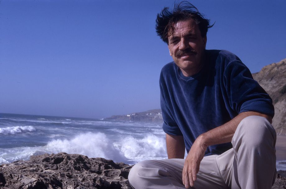
Ian McHarg in Portugal, July 1967. (Photo by Pauline McHarg. Image courtesy Ian and Carol McHarg Collection, Architectural Archives, University of Pennsylvania.)
On the occasion of the 50th anniversary of the publication of Design with Nature, with this new book and its associated exhibition and conference, we ask what might be meant by design(ing) with nature now? As faculty at the Penn Stuart Weitzman School of Design, the school to which McHarg devoted his life, we feel a particular responsibility to explore these questions at this time and from this place. While McHarg’s prescience warrants celebration, our intention in marking the 50th anniversary of his magnum opus is not hagiographic. Rather, we view our responsibility, and the purpose of this volume, as one of constructive and critical discourse — to ask how the ethos of designing with nature has evolved over the past half-century, and to speculate on its prospects over the next fifty years.
By making recourse to nature as a higher authority on the one hand and reducing it to interpretation through data-driven positivism on the other, McHarg was always going to get into philosophical trouble and attract criticism. Indeed, much of what has happened in landscape architecture over the past fifty years can be read as either an endorsement or a critique of his philosophy and method. Had McHarg titled his book Design with Landscape instead of Design with Nature, and had he offered caveats about the limits of his method to inform human creativity and ingenuity, then accusations of hubris and artlessness that were periodically leveled at him could have been largely avoided. But in his rush to change the field — and indeed to change the world — McHarg overlooked some of those critical details.
That McHarg inspired debate is, however, no small part of his enduring significance. Whereas these debates once may have threatened to split the profession between “the designers” and “the planners,” we can now see a profession that has intellectually matured around these tensions. We see a profession that is diversified in its practices but united in its sense of ecological and artistic purpose. We see a profession equipped with a range of design techniques that build on, rather than obviate, their foundation in the McHargian method of landscape suitability analysis. And yes, we also still see the rift between McHarg’s grandiloquence and daily practice — a rift that to some extent must always exist between the ideal and the real. Without gaps between the theory and practice of designing with nature, there would be nowhere for landscape architecture to grow or evolve.
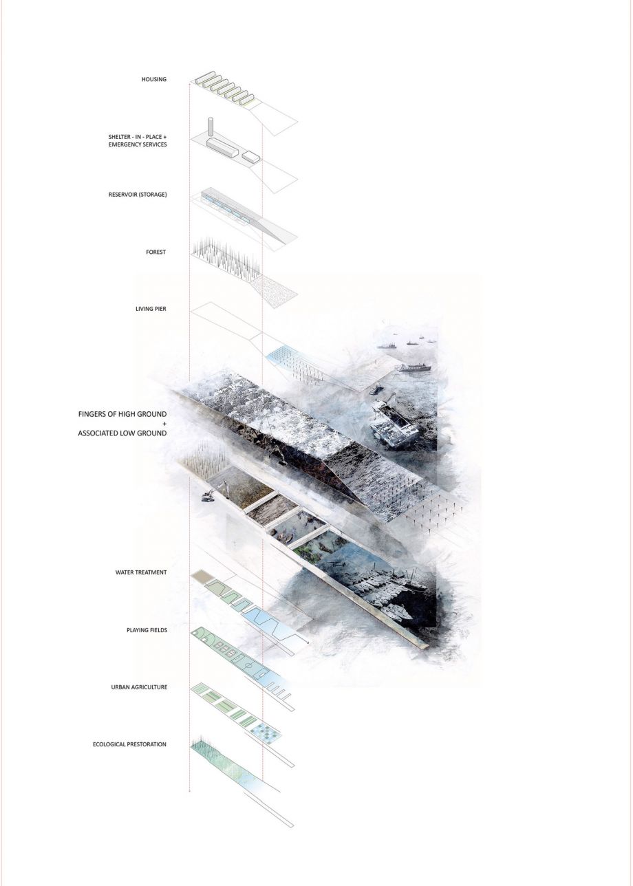
Norfolk, Virginia's Fingers of High Ground and Associated Low Grounds. FHG are natural features of the lower Chesapeake. They can also be a design feature and the basis of a systemic strategy for building a resilient coast. (Image courtesy Anuradha Mathur and Dilip da Cunha)
The projects around which this book is constructed were selected because each in some way narrows this gap and opens up a wider horizon for the future of landscape architecture. Arriving at this set of projects at this moment in time involved a long, collaborative process. We began by asking colleagues from around the world to nominate projects that they thought best exemplified and extended McHarg’s design philosophy and method. […] We have included projects that engage large complex sites and pressing socio-ecological issues, and that variously translate into reality what could be referred to as a McHargian ethos of stewardship. It must be said, however, that some projects show the limitations of the discipline’s ability to effect change at the scale that is needed — the projects improve the social and ecological function locally, but may also be part and parcel of development patterns and infrastructural projects that are environmentally degrading at other scales. […]
Ian McHarg died in 2001, his life’s work completed well before the expressions “climate change” and “the Anthropocene” became central societal concerns. The environmental reality these terms now signify, the debates and anxieties they engender, and the increasing calls for climate action make McHarg’s prophetic injunction to design with nature more pertinent than ever. Paul Crutzen, the atmospheric scientist usually credited with first declaring this to be the epoch of the Anthropocene, has described its advent as beginning with the Industrial Revolution and then radically accelerating after 1945. In 2011, along with his colleagues Will Steffen and John McNeill, Crutzen argued that we should begin moving into a new period in which we “steward the earth.” This, of course, was the essential message of Design with Nature some fifty years earlier, and in this regard, the profession of landscape architecture has been at the vanguard of a broader cultural revolution that now comes into its own in the context of the Anthropocene.
This is not to say, however, that the profession has fulfilled its McHargian mandate of leading global environmental stewardship. Such a claim would be absurd. More to the point, it could hardly be argued that the world is environmentally better off now than it was when Design with Nature was first published. On the contrary, the dawn of the Anthropocene signals the opposite. We are plunging, headlong, into an epoch of global environmental change at an unprecedented scale and pace. How we learn to live with that change is the central challenge for the next half-century of design. In our work there are real clues as to how, through design, we can better tune our cities and their infrastructure to the forces and flows of the Earth system.
This proposal, led by Anuradha Mathur and Dilip da Cunha of the University of Pennsylvania, was one of four projects sponsored by the Rockefeller-funded Structures of Coastal Resilience initiative, which asked teams from four universities to propose coastal adaptation strategies in the North Atlantic region. The aim of the initiative was to provide recommendations that would complement the work to be undertaken by the United States Army Corps of Engineers under the Disaster Relief Appropriation Act of 2013, which was enacted in the wake of Hurricane Sandy.
Instead of establishing a division between land and sea that can be reinforced, defended, or retreated from, the Fingers of High Ground project creates a system of high and low grounds open to the rising sea where settlements and coastal ecologies are interlaced. Fingers of High Ground (FHG) are constructed landforms that accommodate rain and tides rather than confront the sea with a barrier.
FHG are inspired by a careful analysis of the morphology of the lower Chesapeake, an estuary where rivers meet sea, creeks meet rivers, and rills meet creeks in webs between protrusions of high ground. As engineered landforms, FHG likewise operate at multiple scales. They are conceived to extend into creeks, rivers, and the sea while reaching inland to connect with each other at higher elevations. Their form and orientation create slopes and gradients of salinity that can support a range of species and accommodate the migration of their habitats as sea levels rise. In the short term, the higher grounds can provide places of refuge for coastal communities, as well as create retention areas for rain, exit routes for people fleeing storms, and protective barriers from storm surges. In the long term, they can be new grounds for human settlement designed with ecologically sensitive and economically productive infrastructure.
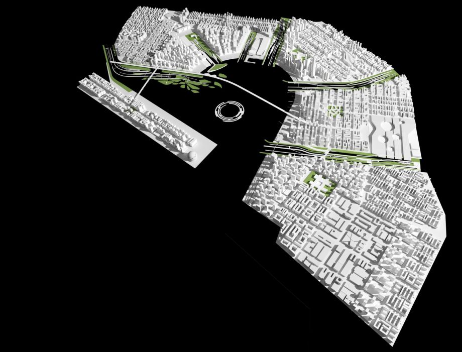
Qianhai Water City Physical Model. Linear green areas show the water fingers. (Image presented with permission of James Corner Field Operations)
Qianhai Bay is located in the Pearl River Delta, west of Shenzhen on the shore of the South China Sea. This area is a key point in the Pearl River estuary at the crossing of the east-west axis of Shenzhen and the north-south axis of Guangzhou to Hong Kong. Officially approved by China’s State Council in 2010, the Qianhai Shenzhen–Hong Kong Modern Service Industry Cooperation Zone was established to serve as a pilot business zone for closer cooperation between Mainland China and Hong Kong in the financial, logistics, and information technology services sectors.
In 2009, James Corner Field Operations (JCFO) won the international competition to develop the master plan for Qianhai Water City. Over an area of 4,500 acres (1,822 hectares) of landfill, the master plan is defined by so-called water fingers. The water fingers are linear parks designed to collect, retain, filter, and cleanse stormwater in a series of terraces and ponds. Widened and extended from the existing water tributaries, these parks define the main zones of public space and delimit future urbanization.
Each of the five development districts shaped between the water fingers is defined by varying scales and typologies of the block structure of each neighborhood to promote walkability, as well as a rich mixture of building type and program (residential, commercial, or other). The five districts are linked by three ring-shaped boulevards for motor traffic. The central transit hubs in each district connect to the regional transit ring of the Pearl River Delta–Shenzhen–Hong Kong megalopolis. Metro lines, the intercity rail line, and an express rail line between Shenzhen and Hong Kong Airport all converge in the transit hubs.
Guiwan Park (pictured at the top of this story) is the first water finger to be built and is anticipated to open in 2021. Its design naturalizes the existing tidal corridor to create various water edge habitats within continuous sculpted topography. The water finger protects against flooding while retaining and cleaning stormwater.
When all the fingers are completed, they will provide the public with large linear parks accessible by foot from the center of each district. The landscape spaces of the Qianhai Water City master plan define the structure, character, health, and logistics of an entire city.
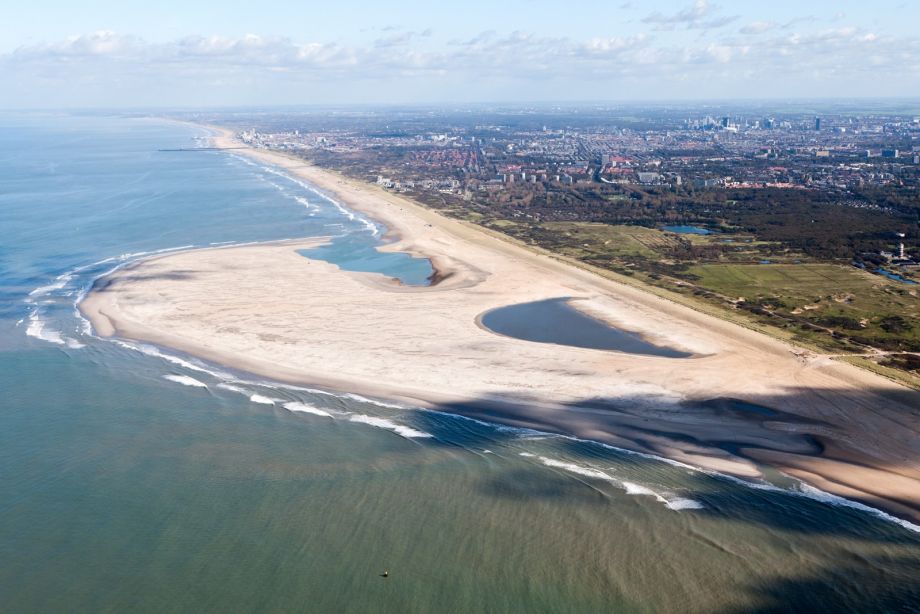
The Zandmotor program in the Netherlands used dredge boats to build up a large peninsula of sand, pictured above, designed to use the natural power of waves, currents, and wind to redistribute sand slowly and continuously. (Image used with permission of the Ministry of Infrastructure and Water Management and Province of South Holland)
Zandmotor (Sand Motor in English) is a novel beach replenishment program completed in the Netherlands in 2011. The project is located between Kijkduin and Ter Heijde, just south of The Hague and downriver from the city of Rotterdam.
Much of the Dutch coastline has retreated inland over the past millennium owing to erosion from wind and ocean currents. Every five years since 1990, sand was dredged from the North Sea to rebuild beaches and dunes. In addition, the coastline faces new threats of sea-level rise and intense weather patterns due to climate change. To make the dredging process more efficient, Marcel Stive, professor of coastal engineering at Delft University of Technology, dreamed up the idea of a beach nourishment program that uses the natural power of waves, currents, and wind to redistribute sand slowly and continuously.
The idea behind Zandmotor is quite simple: dredge boats moved 21.5 million cubic meters (28.2 million cubic yards) of sand from the floor of the North Sea into a giant bent peninsula of sand that is 2 kilometers (1.2 miles) wide at its base and 1 kilometer (0.6 miles) in length. The design of this massive sandbar was based on careful calculations of wind, waves, and currents. The peninsula is expected to continue replenishing local beaches and dunes through the 2030s and will have the added benefit of eliminating the disturbance of the sea floor caused by constant dredging.
In addition to the geomorphological goals of the project, the coalition involved in Zandmotor was concerned with ensuring coastal safety, creating areas for recreation and habitat, and above all, improving knowledge about the dynamics of coastal management. The area impacted by Zandmotor is currently the best monitored and most studied section of beach in the world.
Excerpted from “Design with Nature Now.” Copyright © 2019 by Lincoln Institute of Land Policy. Reproduced with permission of Lincoln Institute of Land Policy, Cambridge, Massachusetts.
Frederick Steiner is dean and Paley Professor at the University of Pennsylvania Stuart Weitzman School of Design, and co-executive director of the Ian L. McHarg Center for Urbanism and Ecology. He served as dean of the School of Architecture and Henry M. Rockwell Chair in Architecture at the University of Texas at Austin. He taught at Arizona State University, Washington State University, the University of Colorado at Denver and Tsinghua University. A fellow of the American Academy in Rome, the American Society of Landscape Architects and the Council of Educators in Landscape Architecture, he has written, edited or coedited 19 books.
Richard Weller is the Martin and Margy Meyerson Chair of Urbanism, professor and chair of the Landscape Architecture Department and co-executive director of the McHarg Center for Urbanism and Ecology at the University of Pennsylvania. He is former director of the design firm Room 4.1.3 as well as the Australian Urban Design Research Center. He is an adjunct professor at the University of New South Wales in Sydney and the University of Western Australia in Perth. He has received a stream of design awards and published four books and extensive papers.
Billy Fleming is the Wilks Family Director of the Ian L. McHarg Center at the Stuart Weitzman School of Design. He is the co-author of “The Indivisible Guide” for Indivisible, a progressive, grassroots-organizing nonprofit, and cofounder of Data Refuge, an international consortium working to preserve vital environmental data. Fleming worked on urban policy development in the White House Domestic Policy Council during the Obama administration. His work has been published in The Guardian, the Houston Chronicle, Landscape Journal, the Journal of the American Planning Association and the Journal of Landscape Architecture. His next book, “Sinking Cities: The Nature and Politics of Adaptation Along the American Coast,” will be published by the University of Pennsylvania Press.
Karen M'Closkey is an associate professor of landscape architecture at the University of Pennsylvania and co-founder of PEG office of landscape + architecture, an award-winning design and research practice based in Philadelphia. Most recently, M'Closkey helped to lead the Stuart Weitzman School of Design's involvement in Resilient by Design: Bay Area Challenge (as part of a large team led by the San Francisco firm Bionic). She is also co-editor of LA+ SIMULATION, which explores how technologies influence the ways disciplines design with nature today.
Next City is a nonprofit news organization that believes journalists have the power to amplify solutions and spread workable ideas from one city to the next city. Our mission is to inspire greater economic, environmental, and social justice in cities.
Learn more about us →

20th Anniversary Solutions of the Year magazine