Are You A Vanguard? Applications Now Open
This is your first of three free stories this month. Become a free or sustaining member to read unlimited articles, webinars and ebooks.
Become A MemberTwo huge towers rise from the Willamette River. Taut cables stretch from each, suspending huge slabs of concrete and rebar like scales of justice hung across the waterway.
Crowding this river bisecting Portland, Ore., the towers stand about halfway between a stretch of Interstate 5 known as the Marquam Bridge and the Ross Island Bridge carrying U.S. Route 26 over the Willamette. Once, riverboats plied these waters. Later, cars chugged high above them. Then came the belching fumes of tractor-trailers and lanes packed with even more honking drivers. Now a new bridge is rising, one that may end up best known for the absence of exactly those things.
The 1,700-foot-long span rising from the river will be a conduit for light rail, pedestrians, bikes, buses and, eventually, streetcars — essentially, everything but automobiles. It will be Portland’s first crossing, and one of the first large-scale transportation projects in the country, consciously engineered with future climate change impacts baked into its plans.
This still-unnamed bridge will become the first Willamette crossing in 40 years and the 12th in Portland’s history. TriMet, the regional transportation authority, has budgeted $134.6 million for a piece of infrastructure it believes will be able to withstand intense climatic changes that the area will confront over the next century.
Here in the Pacific Northwest, glaciers atop the towering Cascade Range are melting, their waters flowing toward the Columbia River and the sprawling, intensely managed riverine system that feeds it. Along with the meltwater and rising sea levels, storms in this already-damp corner of the U.S. are getting wetter and more intense. All this water trickles down to one reality: The river that engineers thought they were dealing with when they started building Portland’s new bridge won’t be around for much longer. Recent data shows surface water models shifting more quickly than ever, with more rain falling over shorter periods of time than it had in the past.
Whatever the jargon, this new way of building is reshaping not only tunnels and bridges, but also the way policymakers budget and plan for growth.
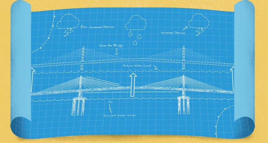
Conservative estimates suggest the Willamette could rise nearly four feet by 2099. As the waters rise and storms intensify, the river’s faster, more forceful flow will erode the soil around the bridge’s support structures. In 2010, bridge designers confronted these projections and redrafted the structure they had spent years modeling. They overhauled the structure to give more room to passing ships and strengthen it against faster-flowing waters. The bridge going up today is three feet higher than originally designed. That small difference in height comes with massive financial costs and implications for the future of infrastructure engineering.
Portland’s projected climate change impacts are comparatively less catastrophic than those foreseen in other cities — think of how Hurricane Sandy caused hundreds of millions of dollars in damage to New Jersey Transit trains that were placed in low-lying yards, or how the storm inundated New York City’s subway stations and tunnels with powerful torrents. Yet Portland’s new bridge offers a revealing glimpse at what one of the nation’s top transportation engineers, Michael D. Meyer, calls a complete “cultural shift” in how infrastructure is planned and built.
If you build new infrastructure today, “you need to do it differently,” says Meyer, co-author of the transportation chapter of the White House-commissioned 2013 National Climate Assessment. For the first time, engineers have started to look at projections for how future conditions may stress infrastructure, and not just rely on historical data to design new projects. Call it smart design or next generation infrastructure. Whatever the jargon, this new way of building is reshaping not only tunnels and bridges, but also the way policymakers budget and plan for growth.
The United Nations Office of Disaster Risk Reduction estimates that natural disasters caused $1.7 trillion in damages around the world between 2000 and 2012. Hurricane Sandy alone took more than 100 lives and cost $71 billion in damages. Those numbers would have likely been much higher had New York City not already, in 2010, started preparing for climate change impacts, creating flood maps to determine which facilities needed hardening before a storm. That knowledge helped officials prepare vulnerable areas for the storm and prevented a tremendous amount of damage. Still, Sandy left corroded tracks, destroyed rail lines and ravaged ferry terminals in its wake. Now, New York’s Metropolitan Transportation Authority is investigating sea walls, floodgates, special shutters and even inflatable barriers that it can deploy to keep future storm surges out of subway tunnels. Meanwhile, researchers at Rutgers University predict that sea levels at the Battery, on the southern tip of Manhattan, could rise 14 inches by 2050 and 36 inches by 2100.
In Los Angeles, projections of imminently rising sea levels have also inspired action. Included in a $40 billion transportation expansion approved by voters in 2008 are adaptation strategies designed to protect the city from future threats. The expansion, funded by a sales tax, will build new light rail lines, extend L.A.‘s subway to the waterfront and streamline connections through the urban core. It also provides some of the nation’s first explicit funding for climate change adaptation. In June 2012, the Los Angeles County Metropolitan Transportation Authority (Metro) even developed a climate action and adaptation plan.
Cris Liban, Metro’s deputy executive officer for the environment, says the plan is essential for the agency to continue providing reliable service. It needs information about flooding in the Sepulveda Basin to know when and where to reroute buses, and it needs to know what to do on exceedingly hot days to prevent buses from breaking down.
Heat is harder on buses and trains than it is on people. The Centers for Disease Control and Prevention use several days of temperatures above 90 degrees, stagnant warm air masses and higher-than-usual nighttime temperatures to define a heat wave, but transit systems start to degrade at lower temperatures than human bodies. Indeed, a 2011 Federal Transit Administration assessment noted that light rail electrical systems, ticket vending machines and even vehicle roofs have all overheated during heat waves in Portland, where systems were designed for a milder climate. Trains were delayed because heat caused the overhead catenary wires that supply electricity to sag.
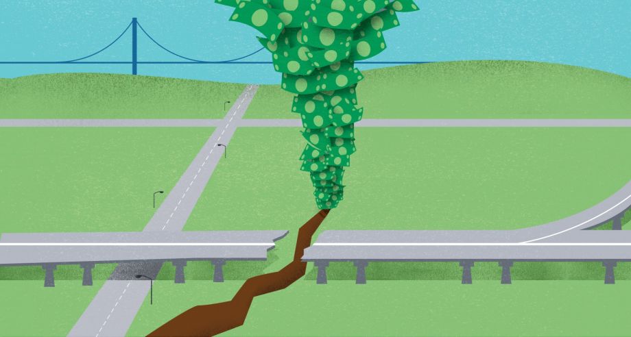
All this poses questions for a city like Chicago, where the number of days with temperatures exceeding 80 degrees is expected to increase by somewhere between 40 and 80 percent by 2100. The city’s $1.38 billion-a-year transit agency is pursuing five adaptation strategies in a citywide Climate Action Plan and doing another assessment of its ability to adapt. High temperatures, after all, warp and buckle tracks. Signal houses can easily overheat if power grids and air conditioners overstrain or fail. Subway portals are the most vulnerable locations — in 1992, more than 250 million gallons of water burst through cracks in a hive of underground tunnels beneath Chicago. But that’s nothing compared to future projections if nothing is done to harden the infrastructure. The best-case scenario, if everything keeps working, is that climate change could drive up fuel consumption by nearly a third, Chicago Transit Authority documents say.
“Personally, I feel that climate change isn’t something we’re anticipating,” CTA strategic planner Karl Peet said during a phone interview in October. “It’s something we’re all facing at this moment.”
Both L.A. and Chicago created their adaptation plans with the help of small grants from the Federal Transit Administration. But the federal money was limited and only paid for assessments to determine improvements that need to get done. Still unfunded is the work itself.
“It falls short of implementation,” Peet said. “What happens next will require some more dialogue.”
“Personally, I feel that climate change isn’t something we’re anticipating. It’s something we’re all facing at this moment.”
Veteran’s Day was Peet’s last day on the job at the CTA. He was laid off during the budget-balancing process, and it’s not clear if the agency will continue work on the pilot he developed. The CTA’s 2014 budget included a commitment to future climate adaptation, but no specifics.
During our phone interview, Peet said the CTA had finished its assessment phase of the pilot, but he was waiting for the FTA to review the study’s results before he could release them. At the time, the review had been sidelined by delays resulting from the federal shutdown. However, in late November, a spokesperson for the agency said that while the CTA didn’t have specifics about future plans, it will look for lessons in the FTA pilot.
“Findings from this project will be rolled into future purchasing procedures,” spokesperson Catherine Hosinski said. “And while we have the findings we need from the federal pilot, we will be considering pursuing other, similar studies in the future.”
Still, the CTA’s latest budget kicks adaptation planning further down the road.
“Extreme weather impacts should be considered in future CTA budget cycles,” reads documentation of the agency’s 2014 budget, adding that officials should continue gathering more data. Still unanswered is the question of how much longer the city can afford to wait.
Drive a hundred miles west of Portland on State Route 30 and you’ll reach Astoria, Ore. As you enter the town’s central business district, you’ll pass a few dozen people lined up in a dirt lot, where a weathered gillnetter on a platform has been converted into a fish-and-chips joint called the Bowpicker.
Highway 30 hugs steep hills blanketed with Douglas firs until it meets U.S. 101 in Astoria. Like Highway 1, its counterpart back East, the 101 runs the length of the Pacific Coast (aside from a few inland stretches, mostly in California). It’s also the main lifeline for Oregon’s coastal towns. In the warmer months, these seaside villages become anchors for weekend escapes and stopovers on trips to quiet beaches and fern-laden hiking trails. When winter storms hit, however, they often become isolated hamlets battered by wind, rain and high, surging waves.
Atop Astoria’s Coxcomb Hill, tourists huff and puff up 164 metal steps to the top of the Astoria Column, a 125-foot observation tower built in 1926. They then step nervously onto a narrow platform. As they follow it around the top of the tower, they can see the mountains of the Coast Range, causeways carrying the 101 across the Youngs River estuary to the south, a regional airfield built in a floodplain, gigantic container ships negotiating the mouth of the Columbia and, finally, the four-mile-long, two-lane-wide Astoria-Megler Bridge, which carries the 101 north into Washington State.
All of this could be vulnerable to sea level rise, more violent storms, landslides and other problems. Extreme weather over a limited period shouldn’t alone be interpreted as proof of climate change, but between 2006 and 2009 there were five disaster declarations in this region, which had seen only 10 such declarations in the decade prior.
Whether warped Chicago El tracks, inundated New York Subway tunnels or New Jersey buses swept to sea, the nation’s transportation-related climate vulnerabilities seem most visible in urban areas. But remote coastal areas are getting much of the U.S. Department of Transportation’s attention right now.
Following Hurricane Katrina, the Federal Highway Administration launched one of the biggest climate adaptation projects anywhere in the country. Ports, roads, airfields, rails and public transit all the way from the Houston-Galveston area in Texas to Mobile, Ala. were examined in the first phase. Last year, the highway administration expanded to study 19 more areas, including this remote, weather-beaten corner of Oregon.
“It has been Ground Zero for Oregon, really,” says the state’s Department of Transportation sustainability planner, Geoff Crook, who helped ODOT develop the coastal hazards vulnerability assessment pilot that the FHWA grant funded. The grant allows ODOT to move beyond a statewide policy framework and focus on this crucial corridor that’s particularly vulnerable to climate change.
These coastal communities, some of which have lagged behind the rest of the state’s economic recovery, are already stretched thin. Now they must add the possibility that rising seas and increasingly frequent deluges could wash away their only paved connections to emergency rooms and grocery stores.
“When you talk about someone being able to get to a hospital, when you talk about someone being able to get to food and water in a natural disaster, Highway 101 is a major problem,” says Marjorie Bradway, ODOT’s sustainability program manager. “There’s just nowhere to go for a lot of these communities when it shuts down.”
“From a human life perspective,” she adds, “they’re key routes.”
“People are preparing for changes in weather. They’ll talk about weather events getting stronger, but they are not explicitly planning for climate change because they, or their superiors, don’t believe in climate change.”
Set to continue through November of next year, the federal pilot program combines quantitative data, such as the condition of drainage culverts or the number of landslides that have occurred in one location over a specified period of time, with decades of qualitative feedback from the people most familiar with highway conditions: ODOT’s local maintenance crews. Given the hazards recorded and projections from climate scientists, crewmembers who have worked here for 20, 30 or 40 years can say which sites in their territory they believe are most vulnerable.
“They’re close to the ground, that’s what they do,” Bradway says. “They know every culvert. They know every pipe out there, so getting their feedback and what they think about vulnerability is important to us.”
At a series of workshops led by Crook, crews who hadn’t ever considered sea level rise as part of their work looked at a specialized online tool that combines maps of their territory with projections of where water levels will reach under various climate change scenarios. Workers could then visualize which areas will be inundated as the sea rises, tell Crook the condition of assets in those areas, and explain whether they think the assets could withstand the higher water levels. Crews may not have been as well versed on climate change scenarios but, Crook says, they understood the issue in terms of extreme storms, which have been particularly brutal in this corner of the state over the past decade. Still, Crook adds, the project is just an early step for protecting the coast’s infrastructure.
When we talk about climate change, we tend to use dramatic language and worst-case scenarios. But in most places, climate impacts will arrive slowly, almost imperceptibly. This, researchers say, makes understanding the incremental changes and countering with responsive changes incredibly important.
“The big events get into the public mind and they cost a lot of money, and they can be very disruptive, but the little events could be like dying from 1,000 cuts or nicks,” says John MacArthur, sustainable transportation program manager for the Oregon Transportation Research and Education Consortium.
I meet MacArthur two cubicles past the research institution’s all-glass entryway, on the third floor of Portland State University’s Maseeh College of Engineering & Computer Science. A “Don’t Walk” signal illuminates one wall, and MacArthur’s workspace is covered with ads for car sharing services and electric vehicle manufacturers. In a maroon shirt, jeans and the sort of thick, black-framed glasses that must be standard-issue among architects and planners in Portland, he fidgets while we talk. Were it not for an apartment building a few hundred feet away, MacArthur could turn around and watch the beam-by-beam, pillar-by-pillar construction of the new light rail bridge over the Willamette.
In 2012, MacArthur and Jennifer Koch, then a PSU grad student, surveyed climate adaptation plans of approximately 300 transit agencies. Only 21 percent responded. Of those who did, a full third said they weren’t collecting or using any data related to extreme weather or climate change, let alone doing anything about it. Those that do don’t always connect the dots to climate change.
“[Adaptation] is totally not getting enough attention,” says Koch, now a planner at Washington, D.C.-based Rhodeside & Howell. “People are preparing for changes in weather. They’ll talk about weather events getting stronger, but they are not explicitly planning for climate change because they, or their superiors, don’t believe in climate change.”
A week before I meet MacArthur, TriMet invited him to present his research on adaptation during the agency’s largest annual forum on regional transportation. Eric Hesse, strategic planning coordinator for the authority, said that while some individual departments were thinking about adaptation, this was the first time TriMet discussed the topic system-wide. It was also an opportunity to bring it to the attention of the board of directors.
But the board will have to make room among its priorities for climate adaptation. As of this writing, it’s unclear how that may happen. TriMet’s $489 million 2014 budget addresses years-long deficits, but agency management continues to struggle with labor disputes. Its employees union is appealing a July 2012 arbitrator-imposed contract, and the agency must still find a way to pay for nearly $1 billion in unfunded pensions. Meanwhile, right after the directors’ forum this fall, General Manager Neil MacFarlane shook up TriMet’s maintenance and operations division following a high-profile series of malfunctions in the system’s light rail network.
Hesse says TriMet department heads still need to digest the adaptation strategies discussed at the directors’ forum. Once they do, he says, they can more broadly institutionalize some of the topics MacArthur raised about climate adaptation.
“We don’t have the work plan for that already drafted up,” Hesse says. “I think, frankly, the region is still trying to figure out the right way to have that coordinated adaptation conversation.”
Our features are made possible with generous support from The Ford Foundation.
Bill Lascher is an Oregon-based journalist who writes about places, people and the forces that act on and between the two. He is currently researching the short, dramatic life of World War II Time magazine Far East correspondent Melville Jacoby. His work is available at http://www.lascheratlarge.com.

Tim Pacific is an award-winning graphic design student entering his senior year at Rutgers University in Camden. In addition to his schoolwork, Tim is an active freelance illustrator. His work can be seen in AIGA Philadelphia’s SPACE, which features a recently completed series of hand-lettered postcards. Among his design philosophies, Tim believes strongly that concept comes first and you should absolutely judge a book by its cover design.
Next City is a nonprofit news organization that believes journalists have the power to amplify solutions and spread workable ideas from one city to the next city. Our mission is to inspire greater economic, environmental, and social justice in cities.
Learn more about us →

20th Anniversary Solutions of the Year magazine