Editor’s note: This post is sponsored by ESRI, a supporter of Next American City. To learn more about ESRI’s products and services, visit their website.
Planners and policy makers must constantly make decisions in the face of uncertainty and ever-changing environmental and socioeconomic realities. Though they must heed the words of elected officials, planners must also listen closely to the citizens they serve. This delicate balance marks a decisive paradigm shift from the tradition of “planning for people,” in which planners do the work and make decisions on behalf of the community, to “planning with people,” in which planners carry out their work in a more collaborative and engaging way. Planning with people requires involving communities from the very onset of the planning process in a manner that is comprehensible, transparent, legitimate, and interactive.
Today’s changing communications landscape—especially the pervasive use of mobile devices and social media—has created new realities and challenges and offered new opportunities to engage citizens in the planning process. Effectively engaging citizens requires the use of collaborative decision-making platforms for actionable intelligence. Planners must effectively exchange information with their entire communities outside traditional in-person community meetings and planning forums. This does not mean replacing the traditional civic engagement processes but rather complementing and reinforcing them with more sophisticated ones that offer resilience and ongoing involvement.
What Is Planning 2.0?
This emerging trend is referred to as Planning 2.0, which incorporates online geographic information system (GIS) mapping and web technologies to support collaborative planning and ongoing public participation. This enhances government transparency and accountability by creating a societal infrastructure for human interaction. Planning 2.0 helps us cast our net as far as possible to capture as much public feedback as needed and foster public involvement. This entails retooling our communities with effective means of communication that go way beyond the traditional civic engagement venues to a more open and capable dialog and transparent participation. Planning 2.0 has three components, or levels, of implementation:
1. Informing impacted and interested stakeholders, including the public, by disseminating information and maps using the GeoWeb as a common platform. Providing meaningful and relevant content about the planning problems and issues impacting the community is crucial not only in informing citizens and community groups but also in getting them interested and involved in the process. The GeoWeb efficiently exchanges community information, provides real-time insight, and reaches more of the public than could possibly attend a town hall meeting.
2. Involving members of the public by getting their feedback and quickly registering their preferences regarding planning initiatives, from broad issues such as community visioning to specific project-based proposals and land-use changes. This is enabled by crowdsourcing, through which citizens act as sensors and a source of geographic information and intelligence.
3. Empowering the public to make informed decisions about new and existing developments. By using the web, cloud computing, and open data-sharing policies as a platform to deliver geoservices, people are able to make decisions regarding what should and should not happen in their communities. This provides a collaborative platform that empowers both decision makers and everyday citizens.
Practical Applications
How can planners leverage Planning 2.0 to connect with their communities? Many communities today have realized the importance of integrating Web 2.0 technologies into planning processes; following are some examples:
Informing and involving the public: Montgomery County, Maryland, created an online Planning 2.0 tool to help track and enforce easements for forest conservation on private land. Conservation easements are one of the planning methods used to preserve prime farmland, forestland, and sensitive natural areas. This method separates ownership of the land from the right to develop it. The idea of this project is to enable the public and property owners to easily view aerial images of their easements and access information about them such as relevant legal documents.
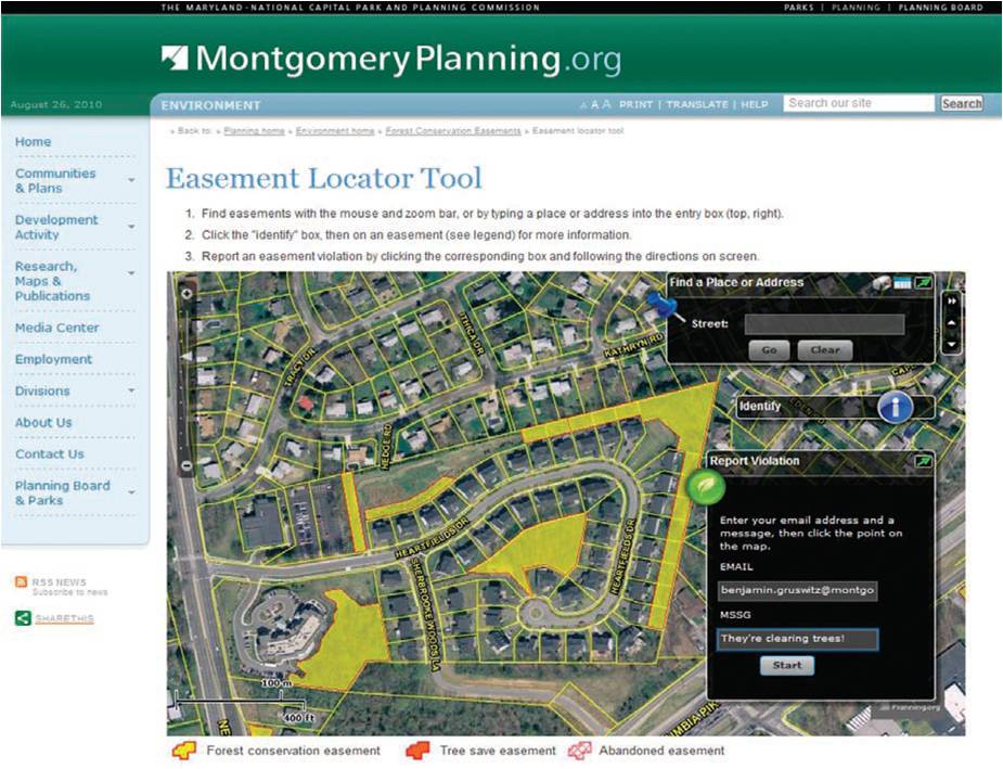
above: Visitors to the site can click a forest conservation easement (yellow) and report a violation directly to the planning department.
The public is able to provide comments by clicking a particular easement on the map and can submit questions or report possible violations. These comments (along with the location) are sent to the planning department’s tracking system, which instantly alerts the planning staff of a violation and quickly generates a return confirmation. Esri’s ArcGIS Desktop and ArcGIS Server are used to manage, analyze, and visualize this data.

above: Selecting a forest conservation easement (yellow) with the Identify tool reveals important parcel information including a PDF of the land record.
Empowering the public: An online application, Priority Places, is an example of empowering the public to make decisions about finding the best places to live and work (namely site businesses). Created by Esri’s partner Azavea, it supports interactive planning in a way that both leverages the investment in GIS technology by the City of Asheville, North Carolina, and empowers citizens and entrepreneurs to make better decisions about where they live, work, and invest. People can select from several indicators, assign weights to each of them, and generate a map showing hot spots reflecting places that meet specific quality of life indicators and business requirements.

above: Citizens and entrepreneurs can select their decision factors and assign weights to each factor to reflect its importance.
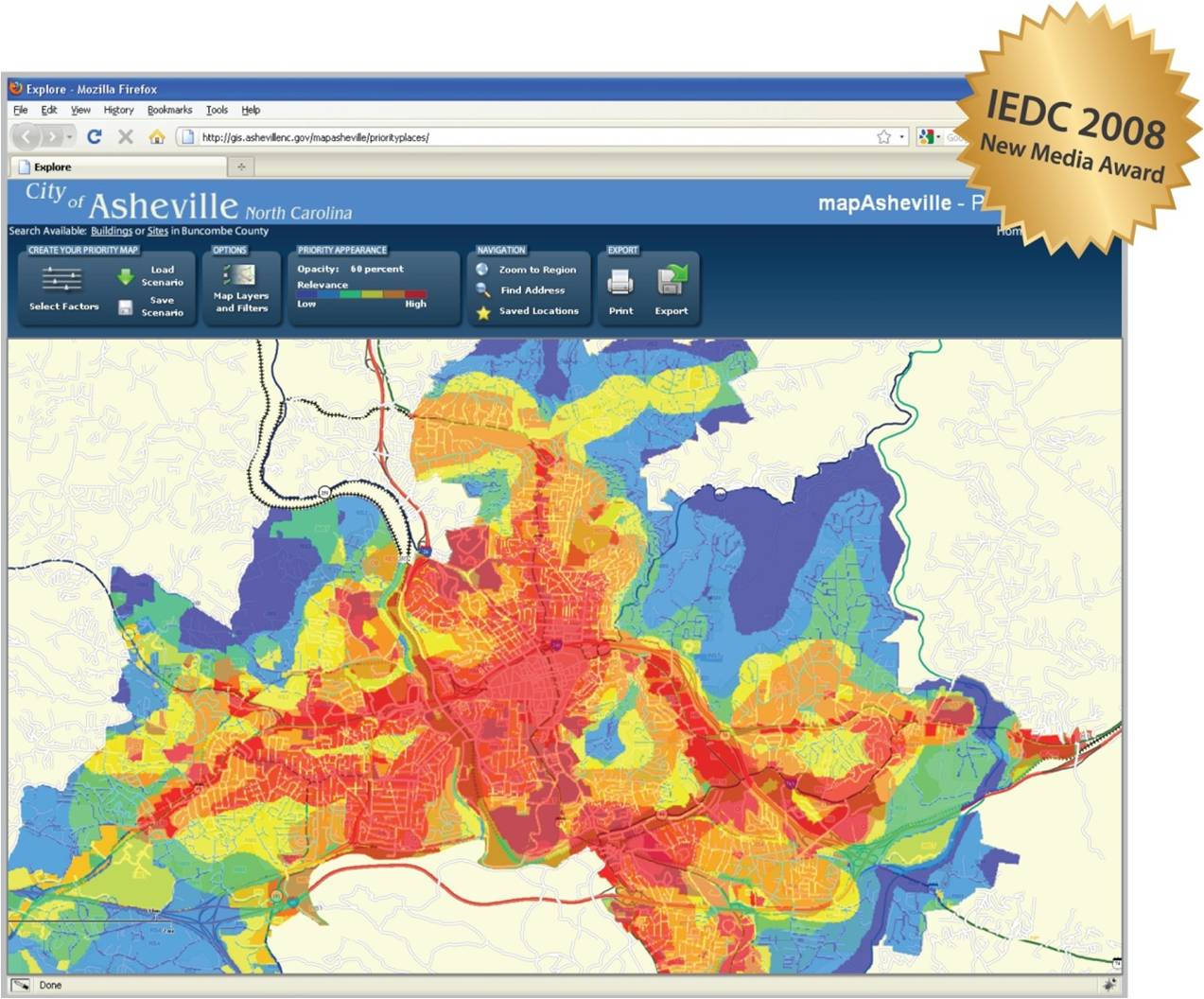
above: A priority map shows the best locations (in red) suitable to live, work, and site businesses based on a selected scenario.
This emerging Planning 2.0 environment aims at bridging the civic engagement and communication gap by fostering bidirectional participation between planners and citizens. Open, accountable, interactive government means that citizens are now empowered in bold new ways to help shape the decision-making process and define future conditions. The challenge for planners today is to embrace and leverage Planning 2.0 capabilities to help them share and connect, creating people-oriented places that are shaped by people-oriented decisions.
About the Author

Ahmed Abukhater is Global Industry Manager for Community Development (Planning and Economic Development) at Esri. You can email him for more information at aabukhater@esri.com.
Dr. Ahmed Abukhater leads Esri’s global marketing strategies in planning and economic development. In his role as Esri’s community development industry manager, he works to advance the industry agenda through his vision of enterprise GIS, smart growth, business attraction, and economic gardening and revitalization. With over a decade of proven leadership in various executive management roles in the United States and overseas, he is a noted expert in a number of areas including environmental science, sustainable development, planning support systems (PSS), and conflict resolution and mediation.
As a planning practitioner, he is dedicated to promoting a holistic approach to addressing community development needs through the creation of effective planning and economic development solutions. His passion for data-driven analysis and decision making has shaped his vision of geointelligence, promoting GIS as the industry-standard technology around the globe.
Abukhater holds a PhD in community and regional planning from the University of Texas at Austin, a master’s degree in urban and regional planning from the University of Illinois at Urbana-Champaign, and a bachelor’s degree in architectural engineering. Throughout his career, he has authored numerous publications, served on many governing and advisory boards, and received over 20 prestigious awards for his work. He is married and a proud father of three children.