Walk through a crowded city in India, and turn off the main road into any small neighborhood. Take a couple lefts, a few rights, and then another left. Do you know where you are? Don’t look for a street sign — there won’t be one. “Addresses are like, ‘I’m 10 meters down from the big tree,’” says Gaurav Gupta about the crowded metropolises of India. “Or there’s streets that don’t have names. They’re named after the biggest shop.”
India’s urban landscape is owed to the complex amassing of people and businesses via urbanization, migration, and population growth, not rigid Western-style urban planning. Far from blocks organized into numbered grids, developing world cities feature great networks of narrow, winding, unnamed roads, developed by the people who occupy and use them. “A lot of these places are informal,” explains Gupta, who is the regional director of global development firm Dalberg Asia.
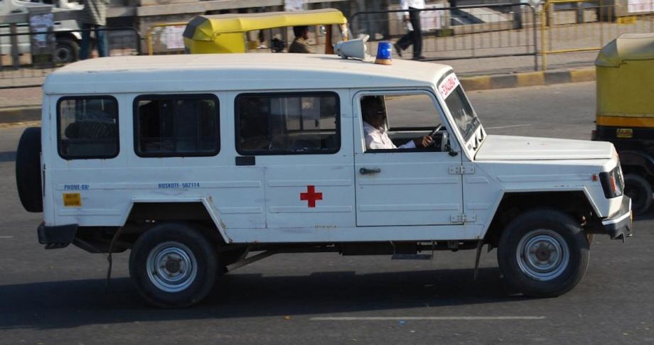
Although vibrant, this informality has its downsides. On tiny, twisted roads, Gupta says, ambulance workers often can’t reach the people who need them. Dalberg Asia hopes to change that. The firm recently released a report, “Smart Maps for Smart Cities,” that analyzes ways in which more thorough mapping (of the variety that Google Maps, Bing and other services already provide) would serve the nation of 1.25 billion, with improved emergency medical service among the wide range of benefits.
Improvements are badly needed. Although India has scaled up ambulance availability in the last decade, the number of units available per capita is still low — just one per 130,000 people, or substantially less than the one per 100,000 population municipalities typically need. As a result, about one in every four calls is turned away for lack of units available to respond.
Dalberg thinks GPS offers two major opportunities: positioning idle ambulances in the most advantageous spots in the urban landscape, and directing dispatched crews swiftly to a patient’s door.
“If you are running an ambulance network, they’re not in the hospitals,” Gupta says. “They place themselves in the spot in the city where they can reach the maximum amount of people in the maximum amount of time.” Indian authorities say this is particularly true at rush hour, when they place state-run EMS units at large intersections. Gupta explains that Dalberg’s improvement is using “real data,” based on mapping and predictive software, to “understand where the casualties are,” based on “millions of things you have to consider.” The method would replace an intuitive, expertise-driven approach favored in lower-tech environments, and offer more accuracy in where idle ambulances ought to park. (Acknowledging that the total number of ambulances is far too low, Gupta calls this “an efficiency play.”)
Ideally, a collaboration among India’s mix of public, for-profit and social enterprise ambulances, along with mapping data, would enhance EMS efficiency.
Perhaps more crucially, Dalberg Asia proposes using GPS technology to help dispatched paramedics reach the right location. “Instead of saying, ‘I’m near a place, now let me ask the locals about it’ — because that’s how it normally works,” he says, GPS could shave minutes off response time.
The two methods combined, the Dalberg report notes, “could save ambulances an estimated 3.5 minutes per call.” With the odds of surviving a life threat rising by 8 percent for each minute saved, the method could cut death in ambulance by perhaps one-quarter — a huge reduction. (Although Dalberg published an estimate that 13,000 people experiencing cardiac arrest or severe trauma would have their lives saved in this way, Gupta adds, “I would say that’s conservative, only because we’re looking at two instances, but there are thousands of things that ambulances respond to … .”)
Indian authorities like the approach. In fact, they’ve already been attempting to cut the wait time of answered calls from 15 minutes down to 10, using intuitive and experience-based approaches rather than GPS.
There is a stumbling block in Gupta’s path: The Indian government restricts the creation and use of maps (and other photographs and videos), citing security, privacy and sovereignty concerns. Map technology, however well-managed, is rendered less useful by these restrictions. The Dalberg report exists in part to quantify how the policy causes hurts businesses, nonprofits and ordinary people.
When or if India allows more mapping, the gains may be substantial — and extend far beyond healthcare. A 2012 Boston Consulting Group study on India found that geospatial information could drive up to $50 billion in direct revenue, and more than $70 billion indirectly. Gupta says mapping could also lead to a more formalized, useful system of street addresses. The shift could dramatically alter urban India. In a nation increasingly focused on corporate development, it might not be far off.
That said, even a policy update and implementation of Dalberg’s approach might not bring perfect results. Although India would be catching up to a practice that Gupta describes as standard in the developed world, he admits GPS can’t defeat an experienced London cabbie.
In fact, India’s future use of GPS might occur just as it gets good. Up till now, mapping can’t even defeat a relatively young city of formally planned grids of streets. In New York, where GPS systems were installed in 2005, ambulance crews reported still using paper maps to find their way to patients.
The “Health Horizons: Innovation and the Informal Economy” column is made possible with the support of the Rockefeller Foundation.

M. Sophia Newman is a freelance writer and an editor with a substantial background in global health and health research. She wrote Next City's Health Horizons column from 2015 to 2016 and has reported from Bangladesh, India, Nepal, Kenya, Ghana, South Africa, and the United States on a wide range of topics. See more at msophianewman.com.
Follow M. Sophia .(JavaScript must be enabled to view this email address)